That makes sense! I can probably do up a Mana Dimension map next. I could do the geography first – do the rivers, layout of the land, major landmarks, et cetera – and get your OK, then move ahead with adding cities.
We can work out names then?
That makes sense! I can probably do up a Mana Dimension map next. I could do the geography first – do the rivers, layout of the land, major landmarks, et cetera – and get your OK, then move ahead with adding cities.
We can work out names then?
Sounds good, Tex!
…though we haven’t mentioned the Dragon Dimension, it’s basically the BoF map. Reborn is a bit messy politically, though, with several new countries and large swathes of no-man’s-land.
Fun fact: The reason Mana Dimension has such a weird map is because Aurora did a map for the Eastern Light Dimension. And if she made her own map, I was damn well also going to make my own map.
Also…http://wiki.kupopolis.club/index.php?title=Woldheim. Actually, in one draft, “Northtown” was at the northern tip of the southern landmass, and “Southtown” was at the southern tip of the northern one. So Northtown was actually south of Southtown. (Part of me wants to make it canon, it’s the kind of thing pedants and geography nerds could bring up at bar trivia nights…sort of like “Greenland is filled with Ice, and Iceland is very green!” kind of thing…)
Yeah, Dragon is one of the ones that changed a lot. Also: are any areas, like, desertified from intense orbital bombardment from the close of White Cell? I wasn’t sure if they busted any cities at the end.
Yeah, let me check a BoF map and decide which cities were probably rubbed out. The whole dimension is probably suffering major environmental damage, maybe even climate shift.
Sounds good! Lemme know. I’ll start on Mana ASAP.
This is sort of reminding me I should find a map for FF7 and rejigger it to fit my mental landscape of how it looks (w/ town/city names etc) by the era it would be in if/when it joins the Web of Worlds.
That’d be cool! Asgar’s a few centuries after FF7 if memory serves?
Correct, only a couple hundred years. I had to come up with proper names for some of the locales so they sound a little less vague. For instance, the Northern Crater-- where Jenova crashed into the Planet in ancient times-- is renamed Katastrofgrop. (Roughly meaning “Calamity’s Pit,” since Jenova is known as ‘The Calamity from the Skies.’) Most of the northern continent’s naming convention is Google Translated to Swedish inspired. (Icicle Inn -> Eisheim, Bone Village -> Nallaheim, Forgotten Capital -> Cetraheim).
Hey, that’s cool. And it fits the quasi-Norse naming of FF7 too.
Did you have ideas for how it’s discovered/enters the Web?
I do, but I’ll move that discussion to a separate topic, so as not to clutter up the maps thread with the talk of it.
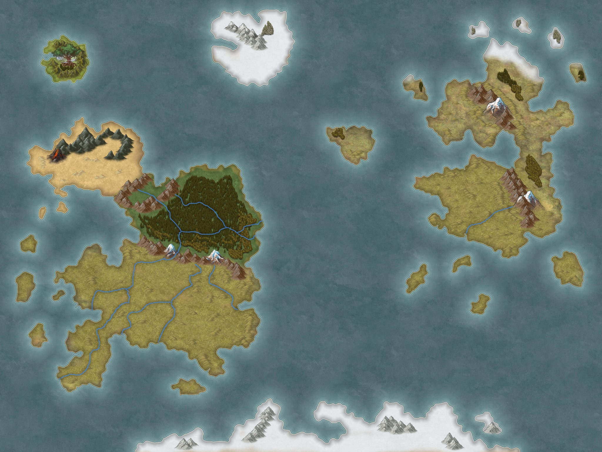
Edit: Whipped up a quick map, threw in a couple of locales from Crisis Core.
This is a big improvement, and it looks nice to boot. One big change, on eminor change
Minor change: One of the islands near the southwestern (Tasnican) portion of the map is referenced as being volcanic, like Hawaii. I don’t know if you want to include that on the map. This is Sebedor Island.
The bigger change, maybe the rivers need a few adjustments:
-Tasnicaport is at the edge of the southwest Peninsula, so one of the rivers needs to exit there
-Centwerp is connected to whatever river goes to Tasnicaport. There should be a big river from the north (originating in Mandala, possibly even cutting through the mountains protecting the Upperlands) and splitting into three, one which goes east into Pandora, one due south (splitting Pandora and Tasnica), and one southwest (to Tasnicaport). In theory, there’s a big-ass lake here, but the Tasnicans have built their city on top of it, so not sure how you would represent it on a physical map.
-I like that you added additional rivers, river navigation was going to be an important plot point in Legends
Additional flavor points, take or leave:
-Woldheim is overall hillier than Euser, but the mountains in Kakkara are the dimension’s tallest
-That said, the northwest part of the southern half of Euser is a bit hilly. (Does that make sense?)
-Of course, the Pure Land is inaccessible by ordinary means, so its presence on the map is kind of like…“we think its probably here, but we can’t actually go there”.
-The Ice Country has a famous bay, frozen-year round, where Celiose defeated the Ticonderan Legions
-Kakkara’s southern coast ("the Queen’s Coast) is actually pretty pleasant, Tasnican co-eds definitely go there for spring break, and the Kakkaran islands are like spice islands
-Aurora’s Legends-era Pandora had some Egyptian stuff going on, so I imagine they have a Nile-like flood cycle with agriculture – Pandora is the breadbasket of the dimension
-TBH, I’m still around and around on Gold Isle. There’s about five or six distinct culture groups in the Mana Dimension (Tasnica/Taznikanze, Woldheim/Krace, Pandora, Kakkara, Ice Country…arguably Kakkara is two because there’s a split between cosmopolitan coast and “savage” interior, and arguably Mandala, Dwarves, and Matango should be included but for most of the story they’re part of Tasnica…) and i’m trying to decide if Gold Isle is just an outgrowth of Tasnica (which I think is what I did, back in the day) or if it’s its Own Thing.
-That said, I do like this map, because as relatively active as Mana has historically been for the story, 90 percent of the action took place in Tasnica, and even then for the most part only in part of Tasnica. In Reborn, it’s actually a plot point that the Woldheimers (and maybe Gold Islanders?) are not really happy they didn’t get the same independence deal as Tasnica’s various extra-dimensional possessions.
…I think at one point the fact this looks nothing like SoM was supposed to be explained by a catastrophic event between SoM and “now”, but then I used a similar map for legends so that rationale is gone.
Huzzah! I’ve got this, with the following changes:
I couldn’t get the volcanoes on the island near Tasnicaport to not look over the top so I left them off.